横田 裕輔
(よこた ゆうすけ/准教授/環境学研究系)
海洋技術環境学専攻/海中・海底情報システム学講座/海中・海底リモートセンシング

略歴
2008年3月 東京大学理学部地球惑星物理学科卒業
2013年3月 東京大学大学院理学系研究科地球惑星科学専攻博士課程修了(博士(理学))
2013年4月 海上保安庁海洋情報部
2019年1月 東京大学生産技術研究所講師
2021年4月より現職
教育活動
大学院:海洋ロボティクス・センシング
JICA課題別研修:海図作製技術 -航行安全・防災のために-
一橋大学:地球科学
研究活動
東北沖地震の物理過程(2011~2013):
GNSS地震学によって東北沖地震の連続した物理過程を解明した(文献1-2)。
衛星レーザ測距技術の開発(2013~):
衛星レーザ測距技術(SLR)の運用・観測技術の開発を行っている(文献3)。
海底測地観測技術の開発(2013~):
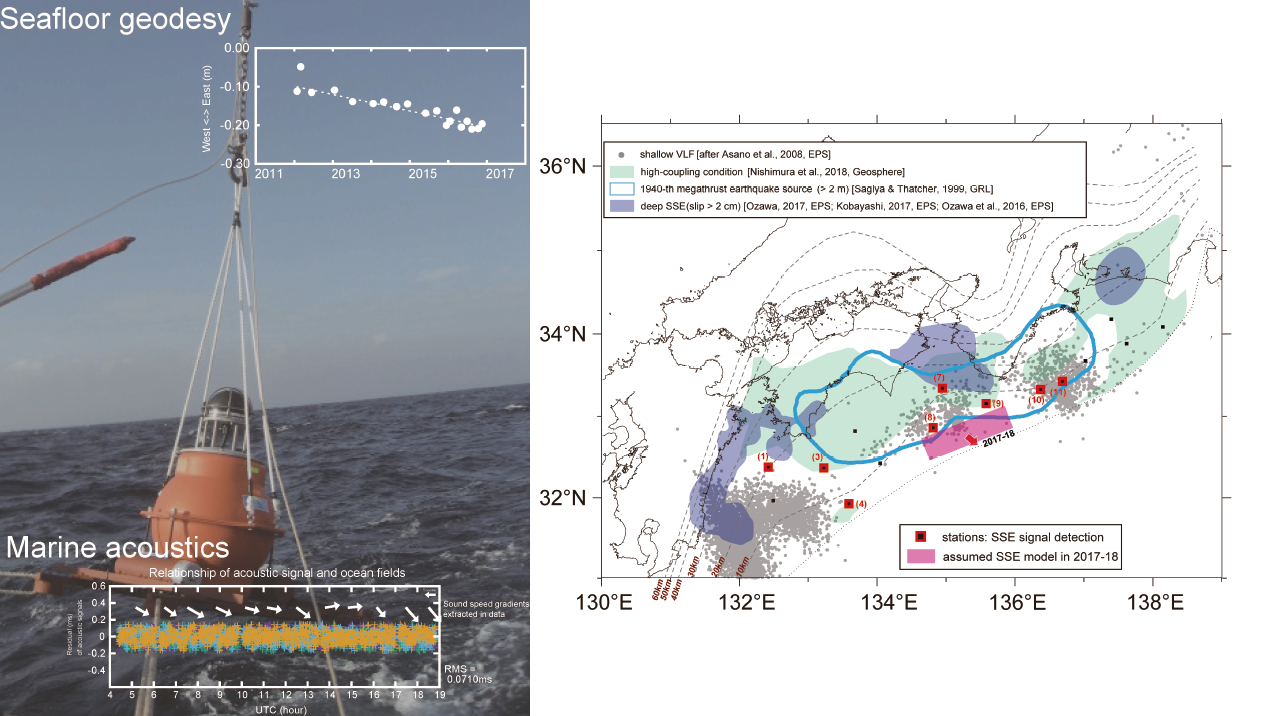
GNSS-A技術を高度化し、世界で最も精度よく、最も高い頻度で海底の地殻変動を計測する技術を開発している(文献4)。
また、GNSS-Aの海洋音響工学的スケール(kmスケール)における海中構造把握技術としての側面を開拓している(文献5-6)。
南海トラフ固着域の解明(2013~):
GNSS-Aによって南海トラフ海底下の固着状態を初めて解明した。これは世界で初めての面的な海域固着状態の可視化事例である(文献7-8)。
南海トラフ浅部SSEの解明(2016~):
GNSS-Aの高度化によって南海トラフ浅部海底下のスロースリップイベント(SSE)を初めて発見した。これは世界で初めてのプレート境界浅部の大規模SSEの検出事例であり(文献9)、スロー地震の計測におけるGNSS-Aの優位性を証明した事例である。
測地観測情報の体系化(2019~):
衛星測地観測情報の国際的な体系化に関する研究を実施している。
海洋観測UAVの開発(2019~):
海洋観測に特化したUAVの開発,その観測手法・応用を提案し、その性能の検証を行っている。
文献
1) Y. Yokota, K. Koketsu, Y. Fujii, K. Satake, M. Sakai, M. Shinohara and T. Kanazawa: Joint inversion of strong motion, teleseismic, geodetic, and tsunami datasets for the rupture process of the 2011 Tohoku earthquake, Geophysical Research Letters 38 (7), (2011). https://doi.org/10.1029/2011GL050098
2) Y. Yokota and K. Koketsu: A very long-term transient event preceding the 2011 Tohoku earthquake, Nature Communications 6, 5934, (2015). https://doi.org/10.1038/ncomms6934
3) 大坪俊通, 横田裕輔: グローバル測地技術としての衛星レーザ測距:現状と課題, 測地学会誌 63(2), 75-79, (2018). http://doi.org/10.11366/sokuchi.63.75
4) Y. Yokota, T. Ishikawa and S. Watanabe: Seafloor crustal deformation data along the subduction zones around Japan obtained by GNSS-A observations, Scientific Data 5:180182, (2018). https://doi.org/10.1038/sdata.2018.182
5) Y. Yokota, T. Ishikawa and S. Watanabe: Gradient field of undersea sound speed structure extracted from the GNSS-A oceanography, Marine Geophysical Research 40, 493-504, (2019) https://doi.org/10.1007/s11001-018-9362-7
6) Y. Yokota and T. Ishikawa: Gradient field of undersea sound speed structure extracted from the GNSS-A oceanography: GNSS-A as a sensor for detecting sound speed gradient, SN Applied Sciences 1:693, (2019). https://doi.org/10.1007/s42452-019-0699-6
7) Y. Yokota, T. Ishikawa, S. Watanabe, T. Tashiro and A. Asada: Seafloor geodetic constraints on interplate coupling of the Nankai Trough megathrust zone, Nature 534, 374-377, (2016). https://doi.org/10.1038/nature17632
8) T. Nishimura, Y. Yokota, K. Tadokoro and T. Ochi: Strain partitioning and interplate coupling along the northern margin of the Philippine Sea plate, estimated from Global Navigation Satellite System and Global Positioning System-Acoustic data, Geosphere 14(2), 535-551, (2018). https://doi.org/10.1130/GES01529.1
9) Y. Yokota and T. Ishikawa: Shallow slow slip events along the Nankai Trough detected by GNSS-A, Science Advances 6, eaay5786, (2020). https://doi.org/10.1126/sciadv.aay5786
その他
GGOS、GGOS Japan 各委員。
GGOS Consortium(2019~)、IAG Inter Commission Committees on Marine Research(2019~)、日本測地学会評議員(2019~2021)・庶務委員(2018~2020)、日本地震学会企画委員(2020~)、海洋調査技術学会評議員(2019~)・編集委員(2020~)、海洋音響学会理事(2021~)・評議員(2017~)等。
将来計画
本研究室では、海底測地学・衛星測地学・海洋音響工学・地震防災工学を基盤とし、多様な海洋情報がより私たちの身近な存在となるよう活動しています。海洋への観測工学・情報工学の拡張、展開を進めています。
教員からのメッセージ
自分が面白いと思える研究・仕事を行うことがとても大切です。色々な面白さに出会ってください。